Take a Deep Dive into the Local Weather Office's Forecast Discussion
The Forecast Discussion gives insight into the analysis behind the day's forecast.

Most people probably never visit the local Forecast Office’s web page on the National Weather Service’s website, but weather buffs know it is an essential stop when researching upcoming weather events.
 Keith R Thompson, WeatherHawks
To reach the Forecast Discussion, go the National Weather Service's website and enter the location (city, state, or zip code). That will bring up the weather forecast for that location.
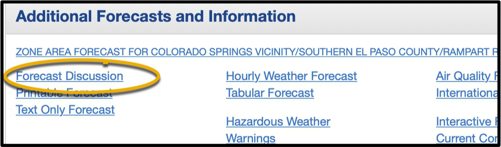
Scrolling down near the bottom of the forecast page, you’ll find a link to the Forecast Discussion (Fig. 1) below Additional Forecasts and Information. The forecast discussion lays out the current and expected conditions, what the models are saying, and, just as importantly, what the meteorologists are thinking when they issue their forecasts.
One thing that stands out is despite the supercomputers running all the different models, despite the atmospheric soundings from weather balloons, tens of thousands of professional weather observations from around the world, and an equal number of CoCoRaHS observations submitted every day, there is still a tremendous amount of uncertainty when compiling a weather forecast. For instance, states like Colorado are unique in their forecast difficulty, which is compounded by wildly varying terrain, significant differences in elevations, microclimates within small areas of the state, valleys, plains, urban effects, and gap winds…all of these are factors in the everyday chaos that is our weather.
Forecasters are upfront about this uncertainty, frequently commenting that their confidence in the forecast models is high, medium, or low. Low confidence levels result when the models diverge significantly from each other. While they generally converge as they get closer to a date or event, this is not always the case. It’s easy to see why, despite the mountain of information and resources available to meteorologists, they occasionally get the forecast wrong. When models are in general agreement, forecasters may indicate high confidence that their forecast will be correct.
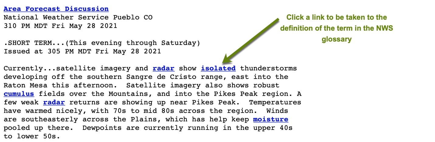
Forecast discussions can be overwhelmingly technical, but reading them regularly can familiarize you with the terms and concepts. Many technical terms are underlined links (see Fig. 2, above) to the definitions of those terms in the NWS glossary. Reading the discussions can be a mini-course in meteorology and many of the technical terms become familiar as you continually encounter them in context with other information. Additionally, the NWS website has a phenomenal amount of information on models, general meteorology, and weather radar that can keep you learning at whatever level you choose. Of all the Federal agencies, the taxpayer probably comes closest to getting their money’s worth with the National Weather Service.
Forecast discussions are generally issued around 0400 and updated around mid-afternoon, with more frequent updates if conditions warrant. If you have a serious interest in weather and forecasting, get in the habit of reading the forecast discussion. You’ll learn a lot, get a feel for how our weather works, understand why the forecaster may get it wrong occasionally, and generally have a better overview of what’s happening in our dynamic atmosphere.