Lee troughs
Lee troughs can be drivers of weather east of major mountain ranges.


One enduring and very influential feature of eastern Colorado weather is the lee trough, an area of low pressure that frequently forms just east of the Rocky Mountains. These lee troughs are often conduits for moist air to be drawn up from the Baja region or the Gulf of Mexico, fueling thunderstorms or snow on the lee, or downwind, side of the mountains.
Though primarily a Rocky Mountain phenomenon, lee troughs also form in the lee of the Appalachian Mountains, the Cascades, and some mountain chains in northern Mexico. In general, these lee troughs are not as strong or pronounced as those near the Rockies and do not have as prominent a role in the weather.
For a lee trough to form, wind flow across the mountains must be perpendicular, i.e. from west to east across the Rocky Mountains. As an air parcel begins to climb the windward side of the mountain range, the height from the ground to the top of the troposphere is necessarily reduced by the rising terrain. A formula developed by Hans Ertel (1904-1971) posits that the angular momentum of a rotating parcel of air is defined by a constant–(ζ + ʄ ) / H = constant where ζ=relative vorticity, ʄ=planetary vorticity, and H = the parcel’s vertical extent or height.
Simply put, if the height of a parcel decreases the speed of rotation decreases and the parcel spreads out, a process called divergence. As the parcel's height increases, as it does when it begins to descend the mountains' lee slope, the speed of the parcel increases and the parcel converges. See this animation from Penn State University's meteorology course for an illustration of the principle.
Ertel's conservation of angular momentum, or vorticity, will cause the parcel of air to turn southward as it reaches the crest of the mountains, then turn northward as it descends the lee slope, forming the low-pressure trough. Confused yet? The following diagram (Fig. 1) may help you visualize the process:
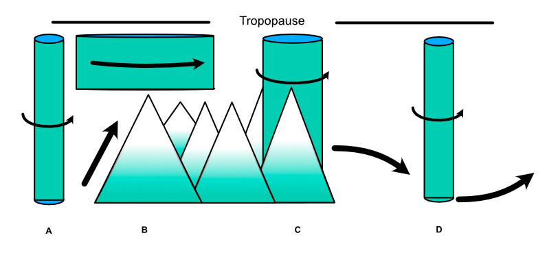
These principles come together in the formation of a lee trough. As air flows up and over the mountains (A), its depth necessarily decreases as the air is squeezed between the mountain top and the tropopause (B). Since planetary vorticity (ζ) remains constant, the relative vorticity (ʄ) must decrease to compensate. Because this decrease is negative, and negative vorticity is anticyclonic, the parcel turns to the right, or south in this case.
As the parcel descends the lee, or downwind, side of the mountains (C), its height increases, as does relative vorticity. An increase in relative vorticity is positive, or cyclonic, and the parcel begins to turn to the left, or north (D), thus tracing the trough on the lee side of the mountain range.
Note, also, that as the parcel moves southward, toward the equator, the vorticity imparted by planetary rotation decreases ever so slightly, while it increases when the parcel proceeds northward.
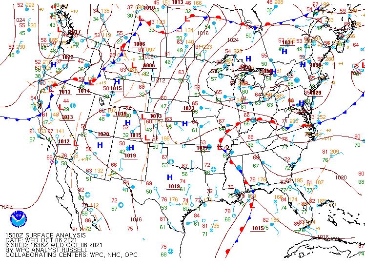
The surface analysis chart (Fig. 2, 1500Z, 6 October 2021) clearly shows a lee trough over eastern Colorado. This trough will pull air from the high-pressure areas located to the west and southwest. This horizontal flow, known as advection, will draw warm, moist air from the south. Indeed, at the time of this chart, rain showers were forecast for the San Juan Mountains in southwestern Colorado.
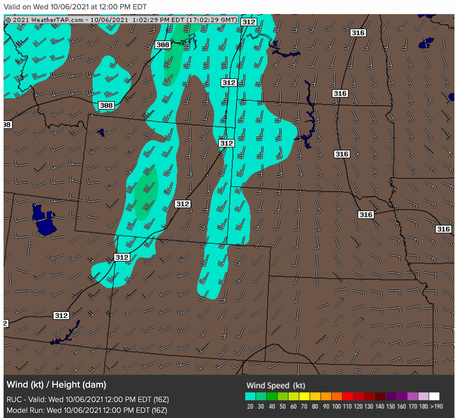
The 700MB (~10,000') upper air wind chart below (Fig. 3) from Weathertap.com (subscription) shows the winds out of the west as the airflow enters western Colorado. To the east of the mountains, the airflow is from southwest to southeast drawing in moist, warm air, a classic lee trough setup. As this trough has strengthened during the week of 3-9 October, the weekdays have gotten warmer and somewhat cloudier.
Lee troughs east of the Rocky Mountains are not confined to the immediate area. Troughs can drift eastward or northeastward with the prevailing weather pattern and affect conditions hundreds of miles to the east of the Rockies until the low pressure washes out.
During the summer months, lee troughs can be a great source of energy for thunderstorms when the warm, moist air is pushed aloft as it encounters the higher mountain terrain. Combined with the convection provided by the sun heating the ground beneath the air, all the elements are in place for noisy summer afternoons.
In the winter, the airflow pushing up against the front range of the Rockies can result in upslope conditions that provide ample snow along the I-25 corridor and into the foothills.
Those of you who read Colorado’s Forecast Offices’ Forecast Discussion will be somewhat familiar with lee troughs; hardly a week passes without some mention. These troughs are an important factor in, and a major driver of, western weather.