Drylines—storm chasers love ‘em
Drylines can be a boon to storm chasers, or a dry hole.


If there’s one thing that storm chasers in the midwest love to see on a surface analysis chart it’s a dryline. Drylines can trigger isolated, but very potent thunderstorms and tornados under the right conditions, making for an exciting day of chasing. Storm chasers can also find themselves sitting in endless sunshine, wondering what went wrong.
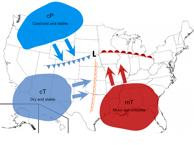
A dryline is a boundary between very dry air, generally Continental Tropical (cT) from the southwest, and moist, unstable Maritime Tropical (mT) air flowing from the southeast. It is distinguished by a difference in relative humidities (dew points) that can be clearly seen on a surface analysis chart.
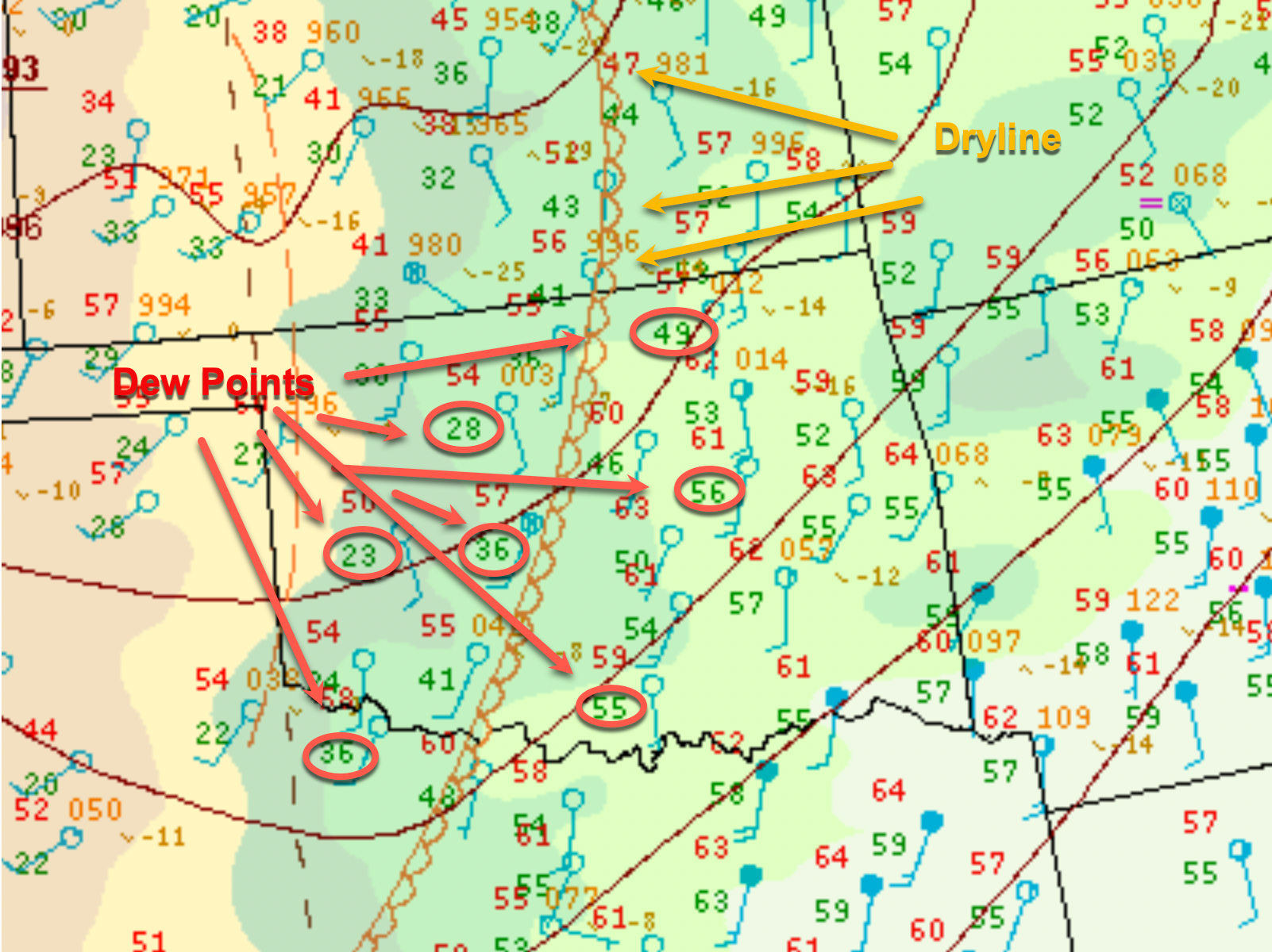
A dryline is drawn through an isodrosotherm, which is a fancy way of saying a line of equal dew points. The map above shows a typical dryline formed in a common midwest location. Drylines are almost always oriented north-south and frequently located through the Great Plains states of Nebraska, Kansas, Oklahoma, and Texas. Spring and summer are prime months for dryline formation, but they can occur much later in the year. The surface analysis map above, for instance, is from January 10, 2022.
Note on the map above that station dew points to the west of the dry line are roughly half those of the stations to the east of the dry line. The air to the west is typical dry, stable cT southwest advection, while the airflow east of the line is from the southeast with higher humidity flowing in from the Gulf of Mexico. The cT air mass may move into the southwestern US from the dry Mexican desert, or may be the result of air crossing the Rocky Mountains and drying out and warming as it descends the eastern slopes. This is a classic dryline setup, with converging airflows from the southwest and southeast.
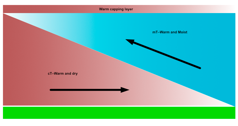
The atmosphere to the east of the dryline contains more moisture and thus is less dense than that to the west of the line. It is also less stable, which is conducive to convective activity if enough forcing (lift) is provided. As the dryline moves to the east, it acts like a frontal boundary, lifting the less dense air to the east as the dry air wedges beneath it. If the moist air is lifted rapidly enough and is unstable enough, this lifting can trigger convection and may launch severe thunderstorms and even tornados. Unlike a frontal boundary, which may divide air masses of widely differing temperatures as well as humidities, the air masses on either side of a dry line may vary little in terms of temperature, but widely in terms of humidity.
Another difference between frontal lifting and dryline lifting is frontal lifting can provide a very strong forcing mechanism between cold and warm air masses, which makes thunderstorm formation more likely. Dryline lifting, by contrast, is a weaker forcing mechanism, since the primary difference between the air masses is moisture content rather than temperature.
Frequently, the dryline may be overlaid by a layer of warmer air between 8,000 and 15,000 feet. The warm layer can act as an inversion, capping upward movement and suppressing thunderstorm formation. Often, in fact, a dryline will be unable to generate sufficient lift to create thunderstorms and will sit idle on the plains. If the lifting is sufficient to break through the cap, supercell formation can be rapid and lead to thunderstorms and tornados ahead of the dryline.
A dryline bulge occurs when dry air at the boundary is advancing faster than along other portions of the boundary, resulting in a bulge in the dryline protruding into the moister air. This stronger push can result in a greater chance of severe weather along and ahead of the line. This momentum may be provided by counterclockwise wind flow around the parent low pressure system.
The dryline's weaker forcing means that only a few individual cells may break through the warm air capping and grow into thunderstorms, but individual cells have a better chance of becoming supercells than does a line of cells ahead of a front, which have to compete with each other for available moisture.
Drylines tend to migrate east during the day and retreat westward during the evening hours as the sun sets, heating is reduced, and low-level winds on the moist side of the boundary start to exert their influence. Given sufficient energy, drylines can occasionally push as far east as the Mississippi Valley, where thunderstorms and tornados can be particularly vicious. Dryline passage results in a significant drop in humidity, clearing skies, and a wind shift from southeast to southwest. The opposite occurs when the dryline retreats to the west. A strong dryline can persist for days, moving back and forth generating storms day after day.
Eventually, mixing between the two air masses weakens the dryline and it dissipates. This can also be caused by the cold front associated with a low pressure area eventually sweeping over the dryline and erasing the dew point differences between the two air masses.
Storm chaser’s delight
Storm chasers love drylines because the isolated thunderstorm cells are usually contrasted with picturesque blue skies and supercells can generate isolated tornados which are a storm chaser's/photographer's dream. Frontal storms, in contrast, are frequently bunched up in lines and may be imbedded and hard to distinguish due to poor visibility. The downside for storm chasers is the feast or famine aspect of drylines. Depending on the strength of the dryline, the difference in humidity on either side, and the depth of the capping warm air, some days you get storms and some days you get a sunburn.